Engage in the Healthy Brunswick River Citizen Science Program
We are thrilled to introduce you to the launch of our exciting new Healthy Brunswick River Citizen Science Program. Our inaugural training workshop is set to take place on August 26th, 2023 in Northern, NSW.
Image: Patchworks Agency
What Can You Expect from the Healthy Brunswick River Citizen Science Program?
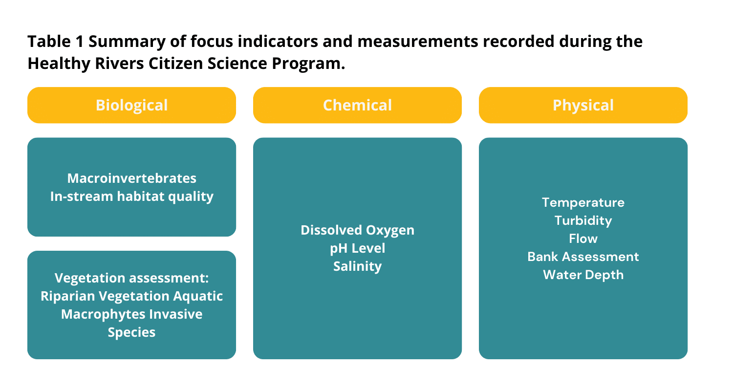
By participating in this program, you will have the unique opportunity to play a vital role in monitoring the well-being of the Brunswick River. Using a range of indicators (summarised in Table 1) you’ll provide information about its current state and identify emerging threats. Dive into the captivating realm of macroinvertebrates, using them as key indicators to unravel long-term trends in water quality. Additionally, you’ll have the chance to evaluate the condition of native and invasive vegetation within and alongside the watercourse.
The initial training workshop will be guided by Brendan Cox, a distinguished expert from River Ecology Australia. Together, we will gather data at five designated sites along the Brunswick River, biannually. The data collection process adheres to a standardised methodology and forms part of a wider initiative spanning the Northern Rivers region. This collaborative effort allows for meaningful result comparisons across diverse catchment areas.
Why do we need to monitor The Bruns?
The Brunswick River is the principal estuary in the Cape Byron Marine Park, and a popular tourist location for fishing, swimming, and boating. The river, associated wetlands and coastline are considered a place of significance for Arakwal people and the Bundjalung nation, recognised under Native Title. Despite the river’s cultural, environmental, and socio-economic value, it is significantly impacted by human disturbances.
This program builds upon our previous ecological research and mapping assessment of the Brunswick River. Key threats identified in this study included riverbank erosion due to lack of protective native vegetation, land use changes, invasive weeds and excessive boat wash contributing to heightened vulnerability to significant weather events.
Soil-laden run-off from eroded riverbanks and creeks within the catchment increase sediment and nutrient loads entering the waterway. Contaminants and pollutants also enter the river via run-off and modified access points, including drains, stormwater outlets, sewage overflow and jetties. Fluctuations in water quality indicators were recorded, highlighting the need to monitor overall waterway condition on a regular basis.
Key Indicators – explained.
1. Biological Health Indicators
Aquatic macroinvertebrates are a fun an engaging way to learn about the health of our waterways. They are defined as creatures that live in freshwater, without a backbone that can be seen without a microscope. They are widely used as bioindicators because they are abundant, diverse, easy to sample and identify.
Macroinvertebrates have varied tolerance to stressors and changes in their environment, sampling and identifying the species present gives us an understanding of the wider health of the waterway.
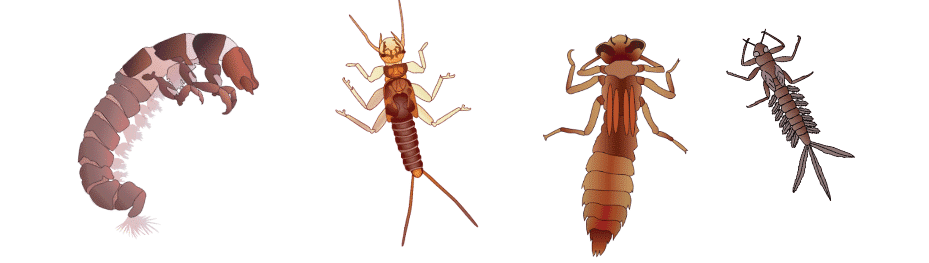
Fig 1. Image of macroinvertebrates, taken from Cox 2023
Native vegetation stabilises riverbanks with roots and provides shade, habitat, leaf litter and organic debris, critical to ecological processes. The riparian zone is an area of natural vegetation running alongside the waterway, composed of plants that require close proximity to water to thrive. A healthy riparian zone creates a natural buffer between land and the water, intercepting sediments, nutrients, and pollutants. Invasive weeds may disrupt natural ecosystems, out competing native vegetation and choking waterways. We will monitor the longitudinal extent and width of riparian vegetation, invasive species, riparian zone composition and record key disturbances. We will also monitor aquatic plants (macrophytes) that live within the waterway.
2. Physio-chemical Indicators
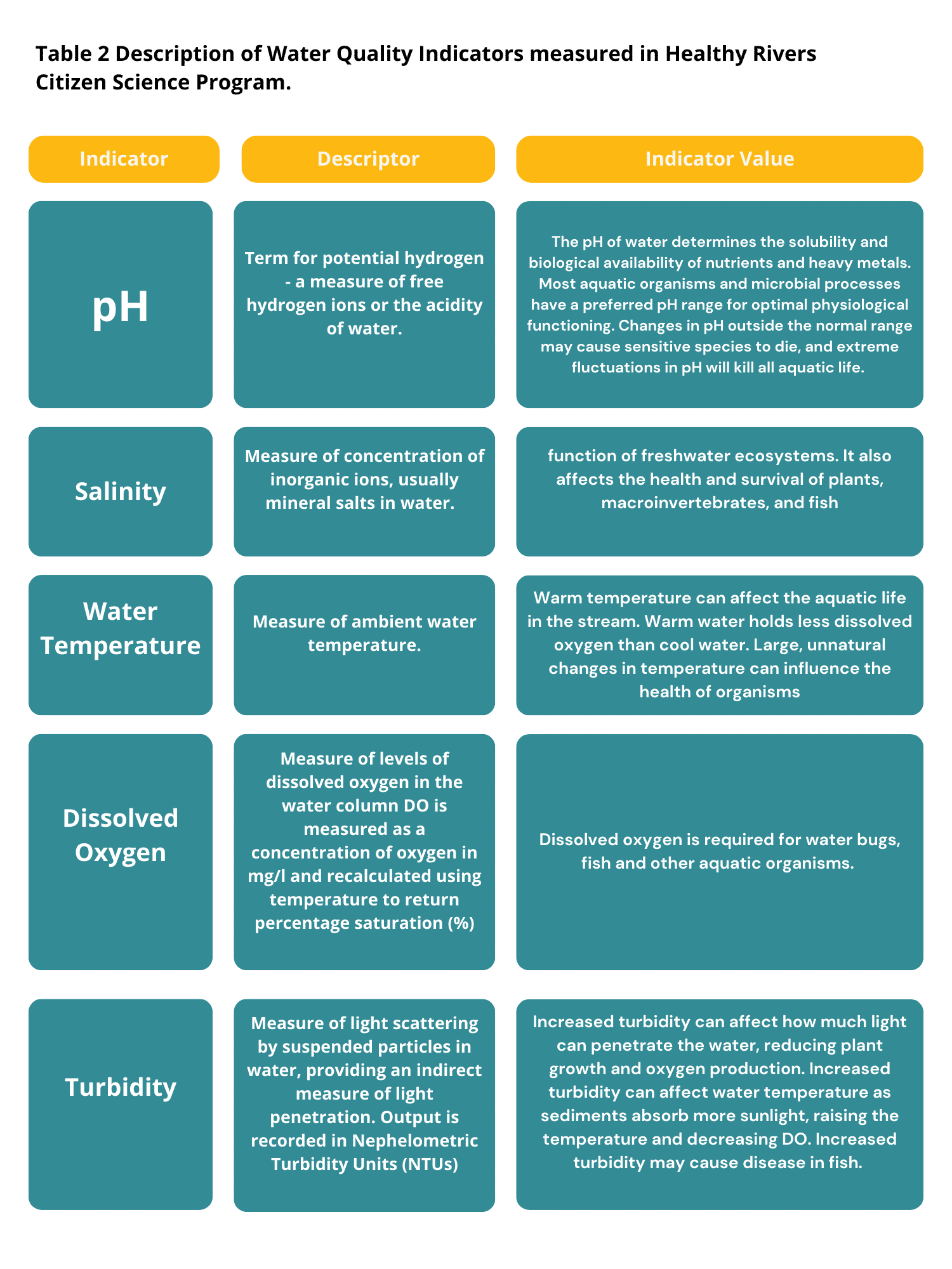
The physio-chemical indicators included in this river health assessment were selected because they are known to have ecological importance in aquatic systems. We will monitor pH, turbidity, dissolved oxygen, salinity, and water temperature as key water quality indicators. Table 2 describes the indicators we will use and provides context to why we have selected them.
What Will You Discover Through Your Involvement?
Engaging in the program will equip you with invaluable technical proficiencies encompassing water quality measurements, assessment of native vegetation, identification of invasive species, macroinvertebrate classification, and evaluation of riverbank conditions. This journey will broaden your understanding of the significance behind upholding catchment well-being, along with the multifaceted elements contributing to this endeavour. By becoming a part of this expansive community effort, you will actively contribute essential data critical to managing and improving the health of our waterways.
Program Goals
- Evaluate the ecological health of the Brunswick River ecosystem by using key indicators to rate designated sites and oversee transformations over time.
- Empower community members to monitor and nurture their waterways by providing training in robust and accessible citizen science methodologies.
We foster positive catchment management by empowering the community to monitor their local waterway in a scientific and quantifiable way. The data collected will help to increase our understanding of the issues facing our local waterways and assist in targeted recovery efforts. Your efforts will be used to annually report ecological river health through a published report card and interactive Story Map ‘heat maps’ illustrating ecological health parameters. The ongoing dataset will show changes in the ecological condition of the Brunswick River catchment over time and draw a link between community works to restore riparian zone conditions and improve river health. The program will also provide insight into the resilience of the Brunswick River catchment to significant weather events informing management for further improvements in resilience and recovery.
Key Dates:
Healthy Rivers Community Training Workshop
Location: Kohinur Hall
Date: August 26th 2023
Time: 10.00am – 3.00pm
Healthy River Surveys
Location: Multiple sites on the Brunswick River from upper main arm to Mullumbiby.
- Round 1: Spring – September, 2023;
- Round 2: Autumn – March, 2024.
Four ways to get involved!
- Are you interested in becoming an active participant in the Healthy Brunswick River Citizen Science Program? Secure your spot for the upcoming workshop by registering here to ensure you don’t miss out!
- Stay Connected with Our Northern Rivers PCFML Volunteer Community! Join the PCFML Volunteer Facebook Group dedicated to Northern Rivers to stay informed about our diverse volunteer prospects. Connect with like-minded individuals and explore various ways to contribute.
- Delve Deeper into the Ecological Mapping Program! If you’re eager to delve into the details of our ecological mapping program, take a moment to explore our captivating interactive StoryMap, available here. Immerse yourself in the beauty of our environment and the significance of our work.
- Support the Health of the Brunswick River! Become a part of the positive change for the Brunswick River by donating to our Healthy Rivers Fund. Your contribution will help us make a tangible difference. Click here to donate and help us preserve this valuable ecosystem.
Image: Patchworks Agency
Acknowledgements
Our Healthy Rivers and Wild Wetlands Citizen Science Projects are being delivered through the NSW Environment Protection Authority’s Flood Recovery Program for Water Quality Monitoring, in partnership with the NSW Department of Climate Change, Energy, the Environment and Water, and supported by the Riparian Stabilisation Package. The Riparian Stabilisation Package is co-funded by the Australian and NSW Governments under Disaster Recovery Funding Arrangements.
We would also like to extend our gratitude and thanks to Go Sea Kayak for donating the use of their kayaks for our river surveys, the Northern Rivers Community Foundation, the Foundation for Rural & Regional Renewal (FRRR) and the Ubuntu Foundation for supporting our program.
Similarly to our program partners for their continued support, including Brunswick Valley Landcare, Southern Cross Credit Union, North Coast Local Land Services, Cape Byron Marine Park Authority, Department of Primary Industries, Byron Shire Council, Wildbnb Wildlife Habitat.
We would like to acknowledge the Arakwal people of the Bundjalung Nation who are the Traditional Custodians of this land on which we live, work, and stand on. Arakwal People retain a strong connection to Country; actively caring for flora and fauna and land and waters. We ask that you respect and help look after Country and Culture. We also acknowledge and pay our respect to Elders both past and present, and the extended Aboriginal community
References
Cox, B., Oeding, S., and Taffs, K. (2019). A comparison of macroinvertebrate-based indices for biological assessment of river health: A case example from the sub-tropical Brunswick River Catchment in northeast New South Wales, Australia. Ecological Indicators 106, 105479.
Cox, B. 2023. Richmond River Ecological Health Manual. River Ecology Australia.
Chessman (2021) SIGNAL 2: A Scoring System for Macroinvertebrates in Australian Rivers – User Manual. V2. NSW Department of Land and Water Conservation
Raven, P.J., Holmes, N.T.H., Dawson, F.H., Fox, P.J.A., Everard, M., Fozzard, I.R., and Rouen, K.J. (1998). River Habitat Quality: The Physical Character of Rivers and Streams in the UK and Isle of Man. River Habitat Survey, Report No. 2. Environment Agency: Bristol, U.K.
Ryder D, Mika S, Richardson M, Schmidt J, and Fitzgibbon B (2015) ‘Richmond Ecohealth project 2014: Assessment of river and estuarine condition’. University of New England
Turak E, Waddell N, and Johnstone G (2004) New South Wales (NSW) Australian river assessment system (ausrivas) sampling and processing manual 2004. (Ed. Editor) pp. 51. Department of Environment and Conservation: Sydney.
Australian River Assessment System: AusRivAS Physical Assessment Protocol Melissa Parsons, Martin Thoms and Richard Norris Cooperative Research Centre for Freshwater Ecology University of Canberra Monitoring River Health Initiative Technical Report Number 22 Environment Australia, 2002, ISSN 1447-1280